Stories of Collaboration: Wazimap
Words by Grace O'Hara • Aug 20 2019
Collaboration is a word that gets thrown around a lot in the world of tech, design and impact. But what does it look like and how can it happen? This series seeks to show the many ways our members are working in collaboration, across the world.
The humble map
By some counts, maps have been part of our lives for 8,000 years. They help us navigate, understand and contextualise the world around us.
And when maps made the leap from paper to screens, they helped do much more than that.
They’ve allowed us to dodge traffic, see images of anywhere in the world and make sense of public transport systems — they’ve even started conspiracy theories.
It shouldn’t be a surprise then, that when William Bird, from Media Monitoring Africa (MMA), bumped into Adi Eyal, from OpenUp, at a hackathon and exchanged shared frustrations of communicating stories with data, the humble map entered the fray as a possible solution.
So what was the problem these two organisations were trying to solve?
Since 1993, MMA has been on a mission to be the media watchdog in South Africa, promoting “ethical and fair journalism which supports human rights”. A huge undertaking considering the state of the news today, where fake news, political agendas and election cycles influence what gets reported and what doesn’t.
Despite issues of labour, unemployment, crime, health, education challenges, transformation, sustainability, land, racism, xenophobia, poverty, inequality, gender-based violence and child abuse being so prevalent, we see that each of these issues receive less than 2% of coverage.
Media Monitoring Africa
Meanwhile, the team at OpenUp have been on a mission, since 2013, to create “tools, open up data, and provide training that support active citizenry and help communities and government work together.”
Both organisations see technology as a vehicle to drive change, and have created tools that empower people to hold those in power to account.
And, both are working towards strengthening communities through honest, and open, information.
The question then was, “how might we combine our skills to solve both our problems?”
Enter Census Reporter
The solution came in the form of open source tool, Census Reporter, who describes its work as making census data easy to use — a missed opportunity to say, making sense of census data, in my honest opinion.
Census Reporter was originally developed as a Knight News Challenge-funded project, to make it easier for journalists to write stories using information from the U.S. Census bureau. How? By breaking overwhelming amounts of data into easy to digest formats, with a focus on three views in particular:
- Geographical profiles, which provide an overview of data points from any particular place
- Data comparisons, which use a variety of formats to show information across a range of geographies
- And topical overviews, which help people understand the concepts and questions from the data-collecting survey used.
Being an open source tool meant that the teams at MMA and OpenUp could copy what had already been created and quickly build upon it for their own needs.
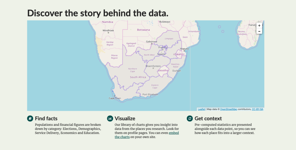
And then there was Wazimap
Wazimap, gets its name in part from the Xhosa language, one of the official languages of South Africa. In Xhosa, ulwazi means knowledge, and it is that sharing of knowledge that really underpins what MMA and OpenUp set out to do.
The question the team ask before adding a feature or extra data is always, “will this still make the data accessible to the citizen?”. Census data, the numbers that quantify specific things about countries and its people, should be accessible to the people — it’s the data of their lives.
According to the collaborative team behind Wazimap:
Since early 2014, Wazimap.co.za has been used by thousands of people across South Africa to understand where they live, go to school and do business. It has become a critical tool for activists, journalists, political parties and many more who need to make informed decisions about their lives and work.
Wazimap breaks down the barriers to access information — perhaps the most compelling argument for this can be made by comparison with the official Statistics South Africa website. Sure, you’ll find a wealth of information there but it’s much busier, more technical, and less visual. All of these things work to make the data less accessible.
Wazimap has helped people navigate, understand and contextualise the world around them — helps people to find the stories in faceless data, and identify the real problems that may be unseen. Things like:
- Unemployment rates in specific towns, and how the community is responding
- The impact of limited access to basic services like waste disposal and toilet facilities
- And, how entire communities are living just above, or falling below, poverty lines
It’s a story that’s continuing to grow
Collaboration was at the heart of Wazimap’s beginning, and it continues now to leverage shared strength to expand its impact and reach.
Wazimap is open source, just like Census Reporter, meaning that anyone is able to replicate and build upon the infrastructure they’ve created. And people and organisations across the world have been paying attention and putting it to good use.
Wazimap has been remixed and adapted to a multitude of contexts locally, through tools like Youth Explorer (which explores youth data specifically) and Wazi — ECD (which explores data around early childhood development), with more happening further afield too:
- Across Africa, HURUmap gives infomediaries like journalists and Civic activists an easy ‘plug & play’ toolkit for finding and embedding interactive data visualizations into their storytelling. The platform draws data from six African countries.
- Counting India has adopted the tool to make data related to the States and Districts in India more accessible and understandable.
- And NepalMap is a friendly and reliable source of information, used by journalists, students, academics and others who want to use data to tell stories or discover stories that are of public interest in Nepal.
The work started by Census Reporter and supported by the Wazimap team has created a community of practice for the tools across the world, with practitioners leveraging shared code and shared learnings.
So what’s next?
Recently, the Wazimap team have been working alongside David Lemayian from Code for Africa, to make it easier to install and spin up new projects using Wazimap. And this work is continuing as we speak, with the team working hard to add new features that will make Wazimap more easy to adapt and setup, and will also make it better suited for third-party data contributions.
The team is also continuing work close to home and exploring a Wazimap that focuses on health point data — for example, where clinics are located, and where certain services are offered.
If you’re interested in using Wazimap in your own community, everything you need to get started is waiting for you online.
Until then, the team are still working ceaselessly to push the boundaries of mapmaking.
Follow along via the OpenUp blog, on GitHub, or the Wazimap newsletter.